National Hurricane Center
Friday, June 9, 2017
SUMMARY OF 800 AM AST...1200 UTC...INFORMATION
----------------------------------------------
LOCATION...18.1N 63.3W
ABOUT 15 MI...25 KM W OF ST. MARTIN
ABOUT 15 MI...25 KM WSW OF ANGUILLA
MAXIMUM SUSTAINED WINDS...185 MPH...295 KM/H
PRESENT MOVEMENT...WNW OR 285 DEGREES AT 16 MPH...26 KM/H
MINIMUM CENTRAL PRESSURE...918 MB...27.11 INCHES
WATCHES AND WARNINGS
--------------------
CHANGES WITH THIS ADVISORY:
None
SUMMARY OF WATCHES AND WARNINGS IN EFFECT:
A Hurricane Warning is in effect for...
* Antigua, Barbuda, Anguilla, Montserrat, St. Kitts, and Nevis
* Saba, St. Eustatius, and Sint Maarten
* Saint Martin and Saint Barthelemy
* British Virgin Islands
* U.S. Virgin Islands
* Puerto Rico, Vieques, and Culebra
* Dominican Republic from Cabo Engano to the northern border with
Haiti
* Guadeloupe
* Southeastern Bahamas and the Turks and Caicos Islands
A Hurricane Watch is in effect for...
* Haiti from the northern border with the Dominican Republic to Le
Mole St. Nicholas
* Turks and Caicos Islands
* Southeastern Bahamas
* Cuba from Matanzas province eastward to Guantanamo province
* Central Bahamas
A Tropical Storm Warning is in effect for...
* Dominican Republic from south of Cabo Engano westward to the
southern border with Haiti
A Tropical Storm Watch is in effect for...
* Haiti from south of Le Mole St. Nicholas to Port-Au-Prince
DISCUSSION AND 48-HOUR OUTLOOK
------------------------------
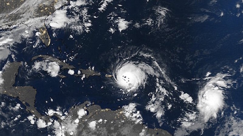
At 800 AM AST (1200 UTC), the eye of Hurricane Irma was located near
latitude 18.1 North, longitude 63.3 West. Irma is moving toward the
west-northwest near 16 mph (26 km/h), and this general motion is
expected to continue for the next couple of days. On the forecast
track, the extremely dangerous core of Irma will move over portions
of the northern Virgin Islands today, pass near or just north of
Puerto Rico this afternoon or tonight, and pass near or just north
of the coast of the Dominican Republic Thursday.
Maximum sustained winds remain near 185 mph (295 km/h) with higher
gusts. Irma is a category 5 hurricane on the Saffir-Simpson
Hurricane Wind Scale. Some fluctuations in intensity are likely
during the next day or two, but Irma is forecast to remain a
powerful category 4 or 5 hurricane during the next couple of days.
Hurricane-force winds extend outward up to 50 miles (85 km) from
the center and tropical-storm-force winds extend outward up to 175
miles (280 km). A wind gust to 90 mph (146 km/h) was recently on
the island of St. Eustatius located south of the eye of Irma. A
NOAA National Ocean Service station on Barbuda reported sustained
winds of 118 mph (190 km/h) with a gust to 155 mph (249 km/h)
before the instrument failed earlier this morning.
The estimated minimum central pressure based on data from an Air
Force Reserve aircraft and earlier surface observations is 918 mb
(27.11 inches). A NOAA National Ocean Service station on Barbuda
reported a minimum pressure of 916.1 mb (27.05 inches) earlier this
morning.
HAZARDS AFFECTING LAND
----------------------
STORM SURGE: The combination of a life-threatening storm surge and
large breaking waves will raise water levels ABOVE NORMAL TIDE
LEVELS by the following amounts within the hurricane warning area
near and to the north of the center of Irma. Near the coast, the
surge will be accompanied by large and destructive waves.
Northern Leeward Islands...7 to 11 ft
Turks and Caicos Islands...15 to 20 ft
Southeastern Bahamas...15 to 20 ft
Northern coast of the Dominican Republic...3 to 5 ft
Northern coast of Haiti and the Gulf of Gonave...1 to 3 ft
The combination of a life-threatening storm surge and the tide will
cause normally dry areas near the coast to be flooded by rising
waters moving inland from the shoreline. The water is expected to
reach the following HEIGHTS ABOVE GROUND if the peak surge occurs at
the time of high tide...
British and U.S. Virgin Islands except St. Croix...7 to 11 ft
Northern coast of Puerto Rico...3 to 5 ft
Southern coast of Puerto Rico and St. Croix...1 to 2 ft
The deepest water will occur along the immediate coast in areas of
onshore winds, where the surge will be accompanied by large and
destructive waves. Surge-related flooding depends on the relative
timing of the surge and the tidal cycle, and can vary greatly over
short distances. For information specific to your area, please see
products issued by your local National Weather Service forecast
office.
WIND: Hurricane conditions will continue today within the
hurricane warning area in the Leeward Islands. Hurricane
conditions are expected to begin within the British and U.S. Virgin
Islands this morning and spread westward over portions of Puerto
Rico later today. Hurricane conditions are expected to begin within
the hurricane warning area in the Dominican Republic early Thursday,
with tropical storm conditions beginning tonight. Hurricane
conditions are expected in the warning area in the southeastern
Bahamas and the Turks and Caicos Islands beginning Thursday night.
Hurricane and tropical storm conditions are possible within the
watch area in Haiti by early Thursday and in the central Bahamas
and Cuba by Friday.
RAINFALL: Irma is expected to produce the following rain
accumulations through Thursday:
Northern Leeward Islands...8 to 12 inches, isolated 20 inches
Northeast Puerto Rico and the British and U.S. Virgin Islands...4 to
10 inches, isolated 15 inches Southwest Puerto Rico, the southern
Leeward Islands, and Saint Croix...2 to 4 inches
Irma is expected to produce the following rain accumulations
Wednesday through Saturday:
Southeast Bahamas, the Turks and Caicos and eastern to central
Cuba...8 to 12 inches, isolated 20 inches
Northern Dominican Republic and northern Haiti...4 to 10 inches,
isolated 15 inches
Southwest Haiti...1 to 4 inches
In all areas this rainfall may cause life-threatening flash floods
and mudslides.
SURF: Swells generated by Irma will affect the northern Leeward
Islands, Puerto Rico, the Virgin Islands, the southeastern Bahamas,
the Turks and Caicos Islands, the northern coast of the Dominican
Republic, and portions of the southeast coast of the United States
during the next several days. These swells are likely to cause
life-threatening surf and rip current conditions. Please consult
products from your local weather office.


